Course Design/Modification
Whether you’re starting from scratch or refining an existing route, I can design a course that meets your event’s needs. A well-planned course considers runner safety, volunteer and police logistics, and avoids bottlenecks or other problem areas. With experience as both a runner and a race organizer, I evaluate every course from two perspectives — ensuring it’s enjoyable for participants and manageable for race staff.
Course Measurement for USATF Certification
USA Track & Field certification ensures your road race course is measured with precision and in full compliance with national standards. When your course is ready to be measured, I will:
- Accurately measure your race course in compliance with all USATF procedures and standards.
- Submit the documentation to USATF for certification and inclusion in the USATF database of certified courses.
- Deliver a clean, detailed course map containing the route and all course splits with detailed descriptions for easy on-site identification. [See examples here.]
- Mark the course on-site
- Start, Finish, and all key split points marked using temporary marking paint and/or survey nails/washers (where permitted).
- Geo-tagged photos with GPS data for every split to make course setup effortless.
Course Marking
If your certified course needs to be remarked before race day, I can handle it — even if it was originally measured by someone else. Course marking includes the Start, Finish, and all key splits, using survey nails/washers and/or temporary chalk spray paint, along with directional arrows at every turn.
Promotional Course Maps
In addition to technical maps for course certification, I can create clean maps for promotional use. All maps are produced in vector format, so they can be scaled to any size without loss of quality. Final files are provided in JPG, PNG, EPS, and/or PDF formats, based on your needs.
Upon request, digital course maps can also be delivered in GPX, KML (Google Earth), or TCX (Garmin) formats — perfect for your planning team or lead cyclists on race day.
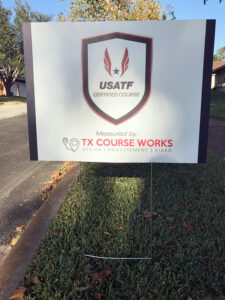
Course Signage
Optional “USATF Certified Course” signage available for display at your event. Signs are 24in x 18in corrugated plastic with metal stakes. Pricing available upon request.